GCS-Lite Lightweight Ground Station
GCS-Lite is a lightweight desktop ground control station for UAV debugging, status monitoring, flight control, and engineering data management. It can manage UAV objects such as FS-J150, FS-J200, and SITL simulation devices, supporting device status viewing, device onboarding, global network configuration, flight-controller parameter management, flight control, data resource management, video monitoring, and notification/alert viewing.
The software is primarily used for UAV R&D, teaching demonstrations, simulation validation, and on-site engineering debugging. It enables centralized multi-device management, MAVLink status monitoring, SITL co-simulation, parameter version maintenance, and management of maps/photos/videos/flight records. With a clean interface, it suits UAV system testing, flight-controller parameter maintenance, and engineering delivery demonstrations.
Software Positioning
Compared with the full-featured, general-purpose PX4/ArduPilot ground station QGroundControl, GCS-Lite is lighter and more focused on centralized multi-device management and on-site engineering debugging:
- Centrally manages multiple real aircraft and SITL simulation objects via device cards + detail drawers;
- Built-in 3D point-cloud map, handheld mapping (SLAM), and relocalization (2D Pose) workflows;
- Provides version-managed flight-controller parameters and centralized archiving of data resources (mapping results / photos / videos / flight records);
- Adapted for Feisilab teaching airframes such as FS-J150 and FS-J200.
Role in the Toolchain
Within the RflySim toolchain, GCS-Lite can co-simulate with the PX4 SITL of CopterSim, monitoring simulated aircraft state over MAVLink. In multi-aircraft scenarios it works with the heartbeat mechanism of DistSim to enable a smooth transition from simulation validation to real-aircraft deployment. It is recommended to first get familiar with the workflow in SITL mode before connecting real devices.
1. Operating Requirements
Hardware
| Item | Requirement |
|---|---|
| Computer | 64-bit Windows, quad-core CPU or above, 8 GB RAM or above |
| Storage | At least 2 GB free; reserve more space according to data volume for videos, photos, maps, and flight records |
| Network | Real-aircraft connections require a usable WiFi or wired NIC; serial/ADB/USB connections require corresponding cables and drivers |
| Simulation | SITL mode requires PX4 SITL or an equivalent simulator, with the simulated MAVLink port available |
Software
| Item | Requirement |
|---|---|
| OS | Windows 10 / Windows 11 64-bit |
| Run mode | Packaged GCS-Lite.exe, or from source via python src\main.py --mode SITL |
| Dev environment | Source mode recommends Python 3.13 with project dependencies correctly installed |
| FC communication | MAVLink relies on the simulator or real flight controller sending heartbeats and telemetry |
Network, Permissions, and Site
- Network: The computer and the UAV should be on mutually reachable networks; common ports include the DistSim heartbeat port, the SITL MAVLink port, and the real-device MAVLink port.
- Permissions: Operations involving local IP, WiFi, or NIC switching may require administrator privileges.
- Safe site: Before real-aircraft flight control, operate in an open, safe, and compliant area, and ensure propellers, battery, RC link, and flight-controller status meet flight requirements.
2. Feature Operation Guide
2.1 Startup and Device Overview
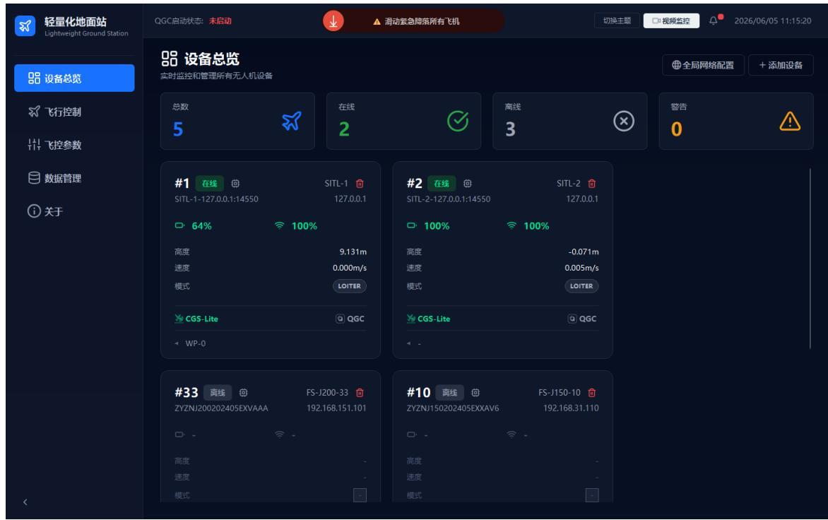
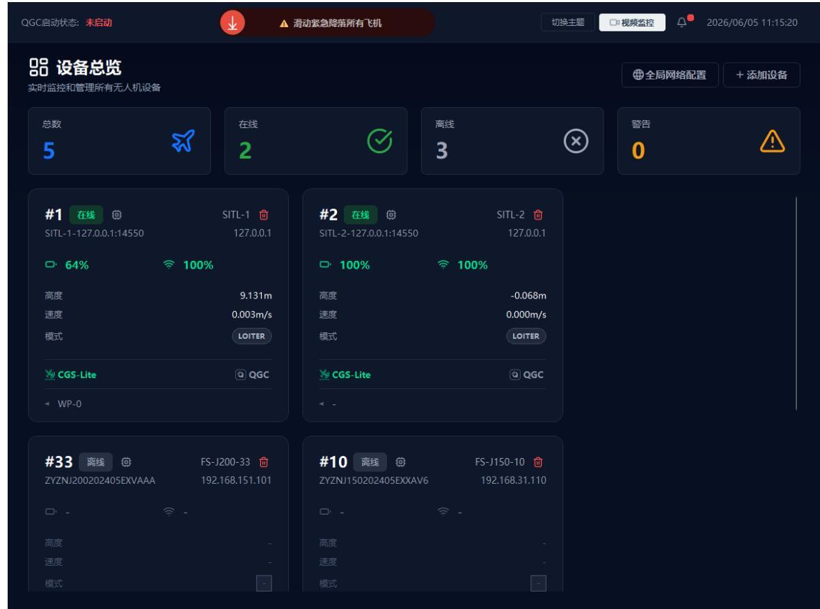
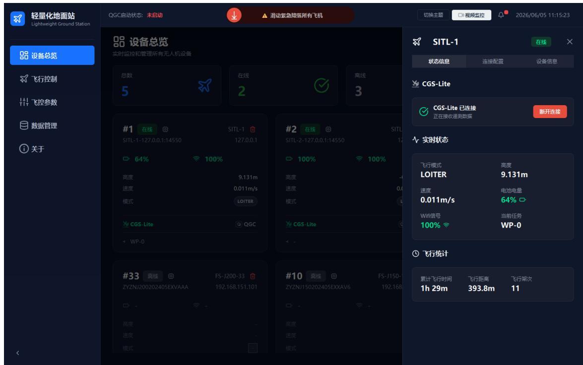
The device overview shows the online status, count statistics, basic telemetry, connection status, and quick-action entries for all UAV devices in the system. It is the main working page after launch.
- Launch the software: from source, enter the
LightweightGCSdirectory and runpython src\main.py --mode SITL; for the packaged version, double-clickGCS-Lite.exe. - View device statistics: the top of the page shows total / online / offline / warning counts, for quickly assessing device connectivity.
- View device cards: each card shows the device number, online status, name, IP address, battery, signal, altitude, speed, flight mode, etc.
Note
In SITL mode, altitude, battery, mode, and other data come from the simulator; real-device data depends on the actual flight controller and communication link.
2.2 Adding a Device
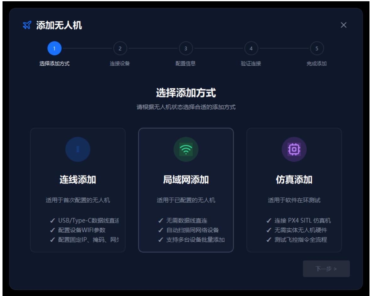
The add-device wizard adds a real UAV or a SITL simulation device to the management list, supporting three methods: wired add, LAN add, and simulation add.
- Click "Add Device" at the top-right of the device overview page to open the "Add UAV" wizard.
- Choose a method: for first-time real-aircraft setup choose "Wired Add"; for devices already network-configured choose "LAN Add"; for testing or demos choose "Simulation Add".
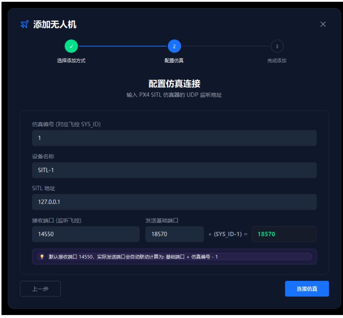
- After choosing "Simulation Add", click "Next" to enter SITL parameter configuration: SysID, device name, SITL address, receive port, and send port.
Note
Do not reuse the same SysID and ports; before adding a real device, confirm that USB, serial, ADB, or network connections are working.
2.3 Viewing Device Details
The device detail drawer shows a single UAV's status, connection configuration, and device information, useful for confirming the GCS-Lite connection, MAVLink data, and flight statistics.
- On the device overview page, click a device card or its settings entry to open the detail drawer on the right.
- Switch tabs:
- "Status": GCS-Lite connection, flight mode, altitude, speed, battery, WiFi signal, and flight statistics;
- "Connection": view connection-related configuration;
- "Device Info": model, serial number, firmware, and sensor information.
Note
When the device is offline or MAVLink is not connected, some telemetry fields may appear empty or show default values.
2.4 Global Network Configuration
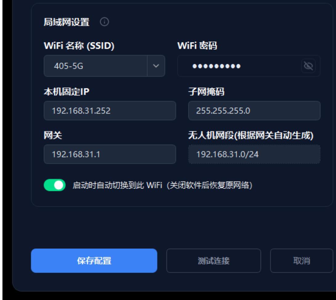
Global network configuration sets the WiFi, fixed IP, subnet mask, gateway, and UAV subnet parameters required for ground-station-to-UAV communication.
- Click "Global Network Configuration" at the top-right of the device overview page.
- In the dialog, fill in or select the WiFi name, WiFi password, local fixed IP, subnet mask, and gateway.
- After confirming the parameters, click "Save Configuration" or "Test Connection" as needed.
Note
Saving the network configuration may disconnect the current device; perform this only after confirming the network parameters, UAV subnet, and on-site communication needs.
2.5 Flight Control
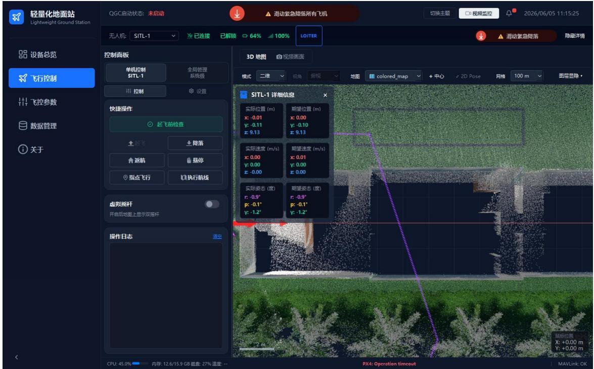
The flight-control page is used to select the current UAV, view real-time flight status, view the 3D map, and execute flight-control actions.
- Click "Flight Control" in the left navigation bar.
- Select the device to control from the UAV dropdown at the top.
- Left control panel: entries such as "Pre-flight Check", "Takeoff", "Land", "Return", "Hover", "Go-to (Point)", "Run Mission", and "Virtual Joystick".
- Right 3D map: shows UAV position, route, trajectory, point-cloud map, and detail overlay.
Safety Note
A pre-flight check must be completed before operating a real device. Do not perform takeoff, landing, return, or mission execution before confirming safety conditions.
2.6 Map, Mapping, and Relocalization
This module is used to view the point-cloud map, switch between 2D/3D views, select aircraft, use the map context menu, draw waypoints, import offline maps, perform handheld mapping, and complete relocalization and 2D Pose-assisted initial positioning in real-aircraft missions.
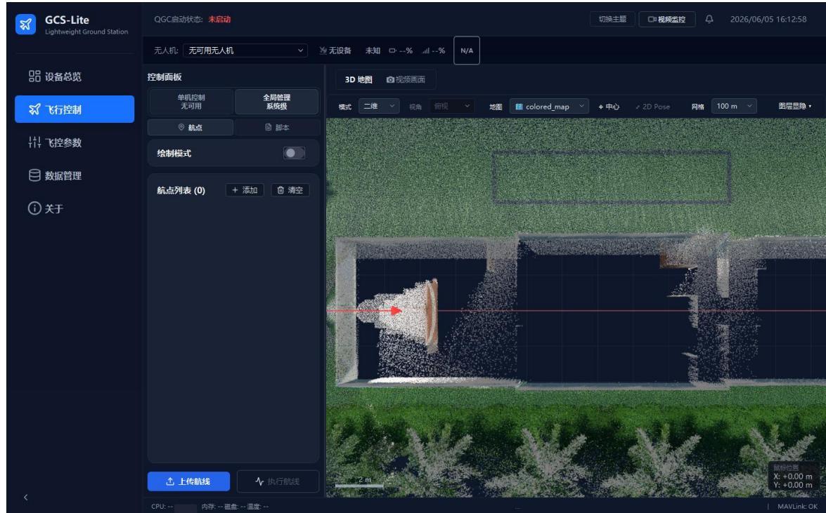
1) Enter the 3D map workspace. In "Flight Control", confirm that the center area shows the 3D map workspace, which contains the top toolbar, point-cloud map, axes, scale bar, aircraft/waypoint markers, and coordinate hints.
Note
If the map is not shown, first check whether a valid point-cloud map is selected in the "Map" dropdown; loading a large point cloud for the first time may take a few seconds.
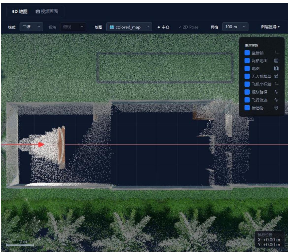
2) Switch the toolbar and layer display. The top toolbar includes "Mode", "View", "Map", "Center", "2D Pose", "Grid", and "Layer Visibility". Click "Layer Visibility" to toggle axes, grid ground, map, UAV model, aircraft axes, planned path, flight trajectory, and markers.
Note
Hiding layers affects only the current view; it does not delete map, waypoint, or flight-trajectory data.
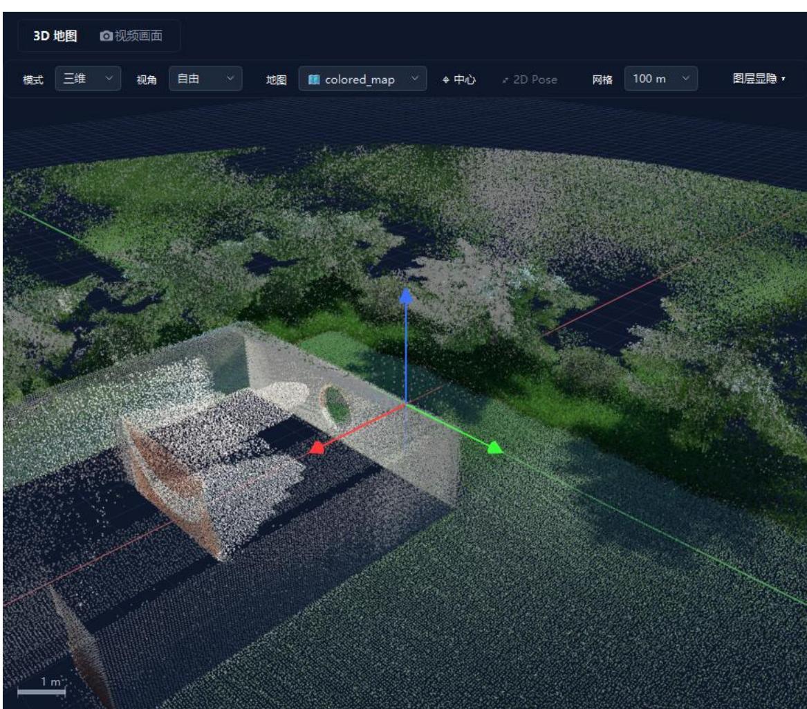
3) Pan, zoom, and switch between 2D/3D. In 2D mode: drag with the left/middle button to pan, scroll or right-drag up/down to zoom. In 3D mode: left-drag to rotate, Ctrl + left button or middle-drag to pan, scroll to zoom; the "View" dropdown quickly switches to top, free, front, right, back, and left views.
Note
Switch back to 2D mode for drawing waypoints and 2D Pose; use the 3D free view to check point-cloud height and spatial occlusion.
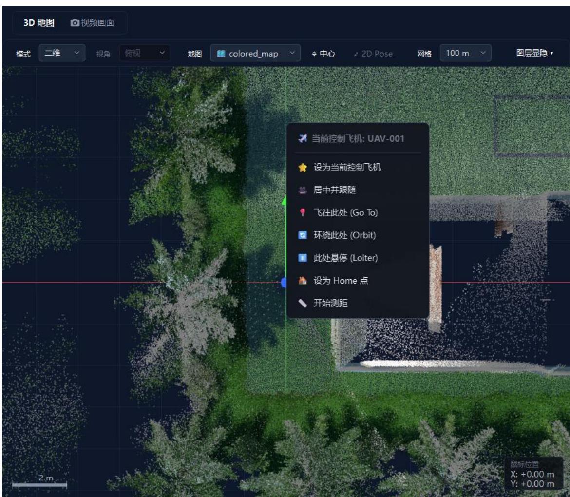
4) Select an aircraft and use the context menu. Left-click an aircraft to highlight it and open the detail overlay; Shift/Ctrl + left-click for multi-select/deselect. Right-click an aircraft or empty area to open the context menu, with common actions such as set as current control aircraft, center and follow, fly here, orbit here, hover here, set Home, and start ranging.
Note
For commands such as takeoff, landing, return, and mission execution, confirm the current control aircraft, connection status, arming status, and on-site safety conditions.
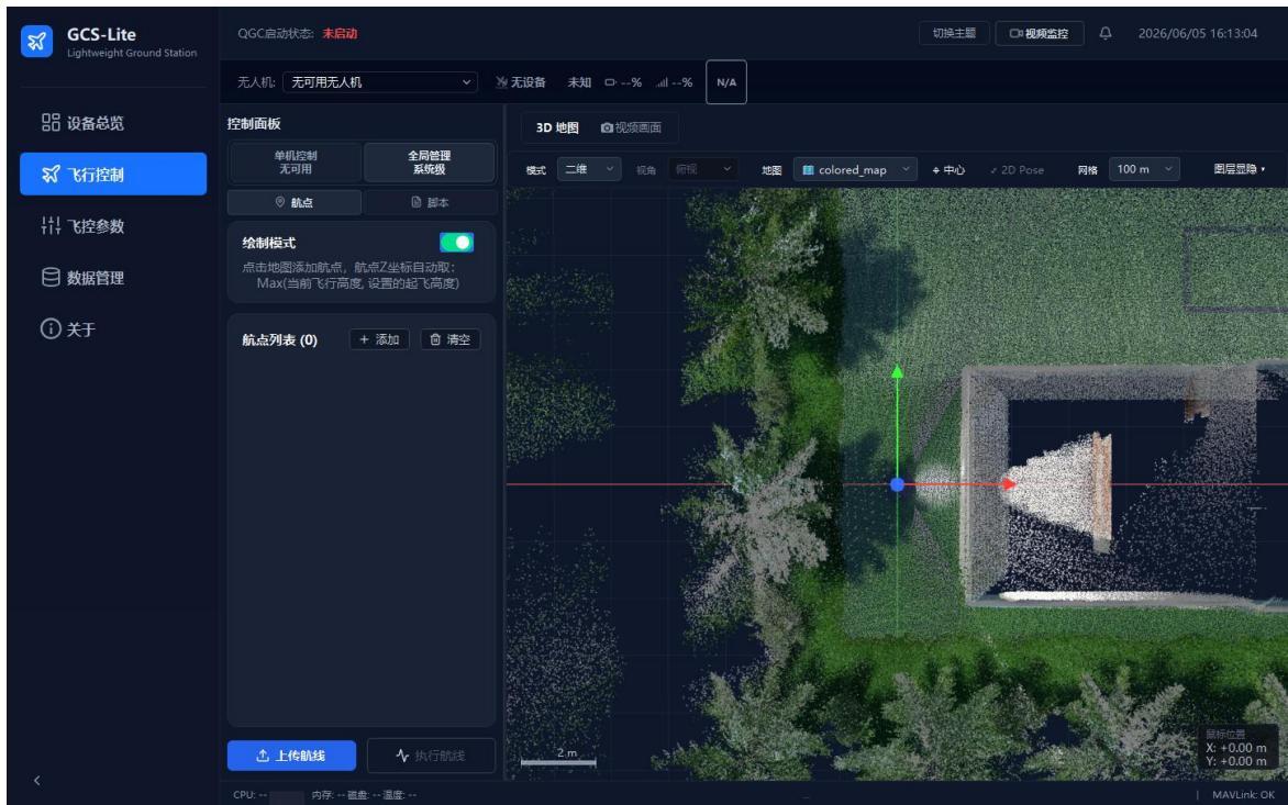
5) Draw waypoints and manage routes. In the left control panel, switch to "Global Management / Waypoints" and enable "Draw Mode", then left-click target positions on the 2D map to add waypoints. Use the waypoint list to add, clear, and upload routes; right-click a waypoint to change its altitude or delete it.
Note
Switch to 2D view before drawing waypoints; to batch-adjust altitudes for multiple waypoints, multi-select them first and then set the altitude in bulk.
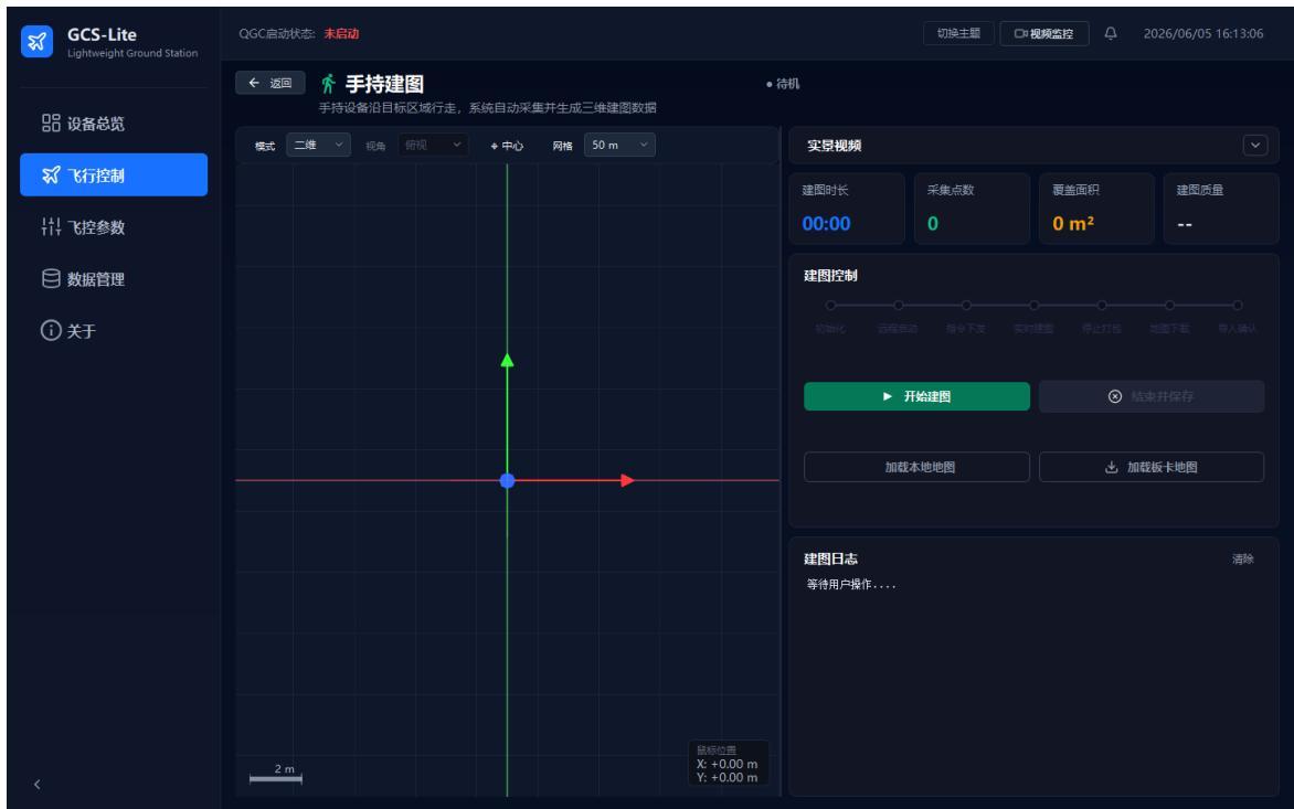
6) Perform handheld mapping. After selecting a real aircraft or onboard-computer device that supports SLAM/mapping, click "Handheld Mapping" on the left to enter the full-screen mapping view. After clicking "Start Mapping", the system shows the mapping stage, duration, collected points, coverage area, quality status, and logs; when finished, click "Finish and Save", then load the local map or onboard-computer map as needed.
Note
SITL or airframes that do not support mapping may not show this entry; real-aircraft mapping depends on the onboard-computer network, SSH/SFTP, UDP communication, and remaining storage.
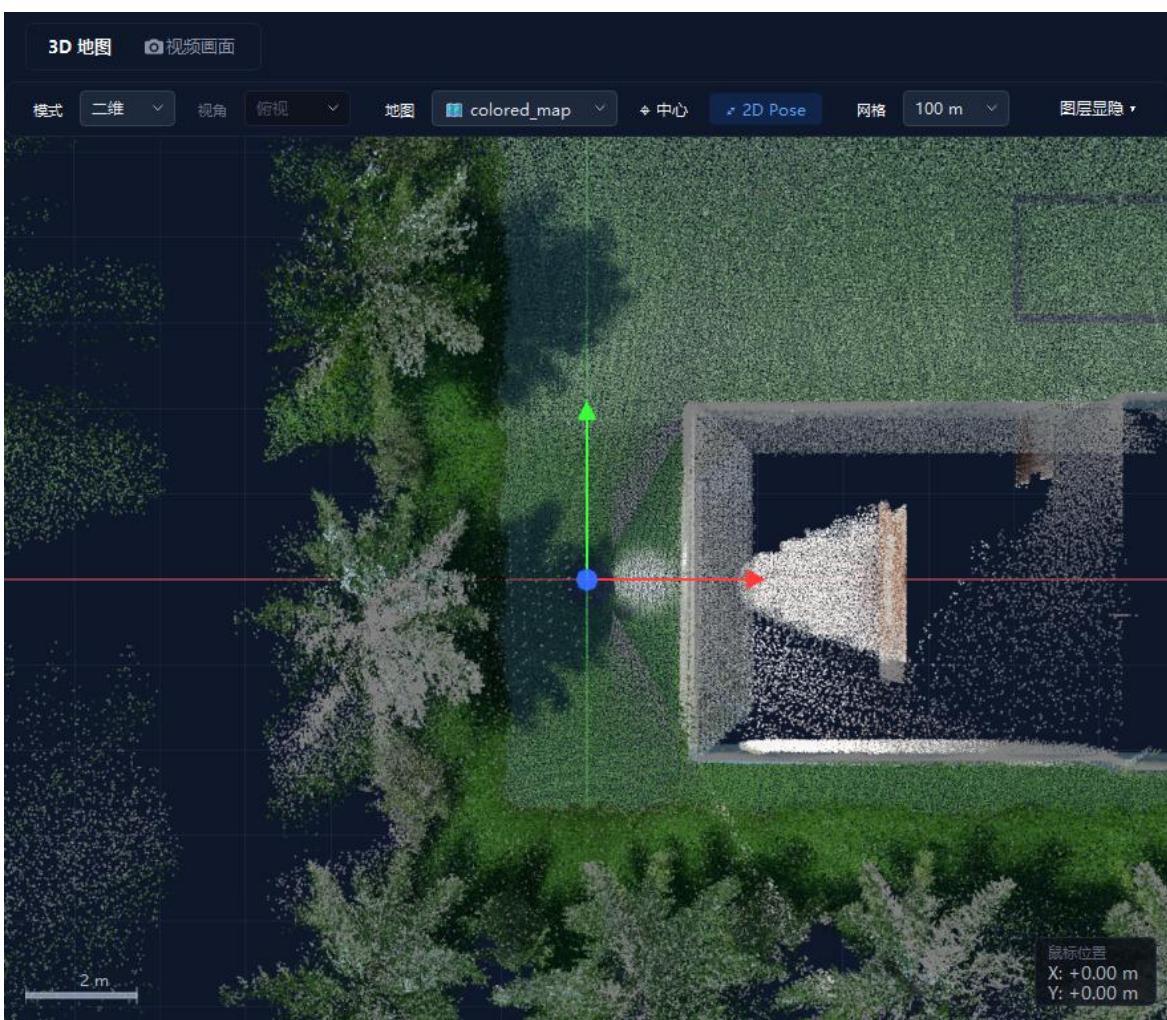
7) Start relocalization and use 2D Pose. Before real-aircraft relocalization, first select an imported map (with an archive package) in the map dropdown, then select the target aircraft and click "Start Localization" on the left. After the process starts, the "2D Pose" button in the toolbar becomes available; click it, then press and hold the left button on the 2D map to specify the aircraft position, drag to set the heading, and release to send the manual initial pose.
Note
2D Pose is available only after relocalization is started; after sending the pose, observe whether the point cloud realigns, and exit the localization process only after confirming success.
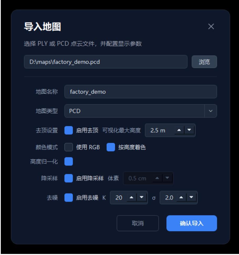
8) Import and manage offline maps. Go to the "Data Management" page, click "Import Map" under the map-management tab, select a PCD/PLY point-cloud file, fill in the map name, and set top-clipping, max visualization height, color mode, downsampling, and denoising parameters as needed. After confirming, the system saves the configuration and refreshes the map dropdown on the flight-control page.
Overall Safety Note for This Section
Map operations, mapping, and relocalization should be performed in a safe environment. Before a real aircraft executes flight control, uploads a map, starts localization, or uses 2D Pose, confirm that the device is online, the network link is stable, the map file matches the current site, and the site meets flight-safety requirements.
2.7 Flight-Controller Parameter Management
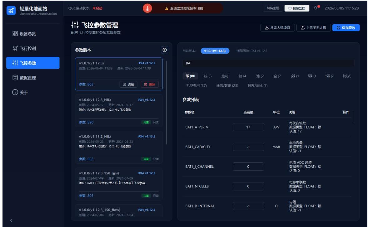
Parameter management maintains flight-controller parameter versions, supporting local viewing, search filtering, reading parameters from the UAV, uploading parameters to the UAV, and saving changes.
- Click "FC Parameters" in the left navigation bar.
- Select a parameter version on the left (the version card shows name, firmware version, creation/update time, and parameter count).
- Enter a keyword in the search box (e.g.,
BATto filter battery-related parameters). - To modify, edit the value in the parameter table and click "Save Changes"; to interact with the UAV, use "Read from UAV" or "Upload to UAV".
Note
Uploading parameters changes the flight-controller configuration; before doing so, confirm that the target device, firmware version, and parameter version match, and back up the original parameters first.
2.8 Data Management
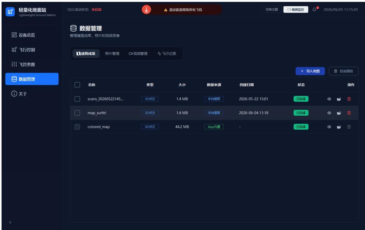
Data management centrally views and manages engineering data such as mapping results, photos, video recordings, and flight records.
- Click "Data Management" in the left navigation bar.
- Switch between the "Mapping Results", "Photos", "Videos", and "Flight Records" tabs at the top.
- View name, type, time, size, and status in the resource list; click "Import Map" to import, or select resources first and use batch operations for bulk processing.
Note
Confirm backups before deleting data; flight records and video files are usually large, so clean up or archive them regularly.
2.9 Video Monitoring
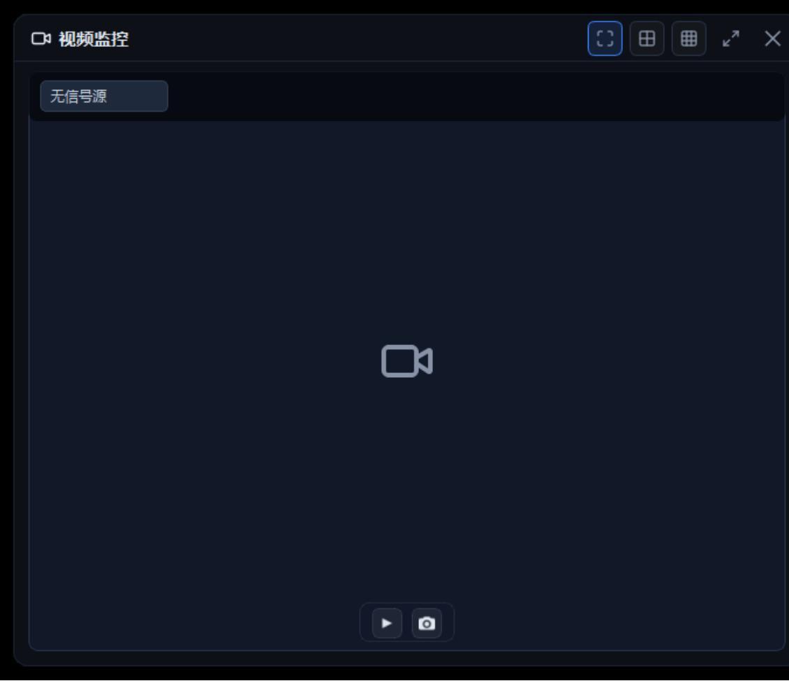
Video monitoring views the UAV camera's live feed and provides layout switching, full-screen, recording, pause, stop, and snapshot actions.
- Click the "Video Monitoring" button in the top status bar.
- Select the signal source and camera channel in the dialog.
- Switch between 1×1, 2×2, 3×3 layouts or full screen as needed; once a video source is connected, use the bottom record, pause, stop, and snapshot buttons.
Note
Whether SITL or real-device video is available depends on the camera configuration, video-service status, and network link; recording consumes local disk space.
2.10 Notification Center
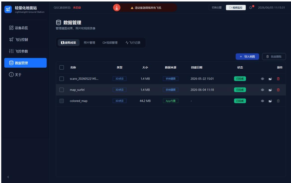
The notification center shows messages, alerts, and status prompts during system operation, helping track device onboarding, flight-controller status, and anomalies.
- Click the bell icon at the right of the top status bar to open the notification center.
- View unread messages and history, and judge whether action is needed based on content (e.g., a device coming online indicates restored communication; a flight-controller anomaly prompt should be investigated together with FC status and on-site conditions).
Note
The same type of notification may appear multiple times; judge the current risk together with the latest time, device status, and the flight-control page.
2.11 About and Version Info
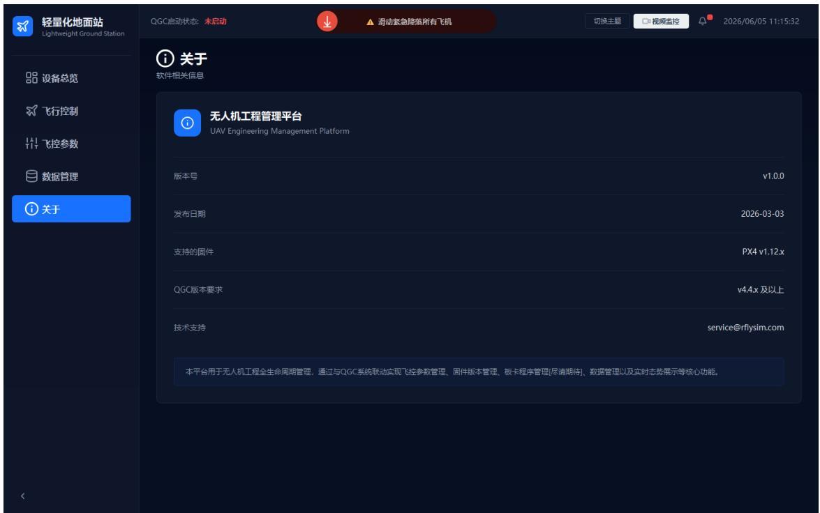
The About page shows the software name, version number, release date, supported firmware, QGC version requirements, and technical-support information.
- Click "About" in the left navigation bar.
- View the software version, release date, supported firmware, and technical-support email.
Submitting Feedback
When reporting issues or feedback, please also provide the software version, run mode, device model, log files, and reproduction steps.
3. FAQ
A device shows offline — what should I do?
- Confirm the UAV power, flight controller, onboard computer, and network connections are normal;
- Confirm the computer and UAV are on the same subnet and the firewall is not blocking the communication ports;
- In SITL mode, confirm the simulator is running and the SysID, receive port, and send port are correctly configured.
A flight-controller parameter can't be found by search — what should I do?
- Confirm the correct parameter version is selected;
- Check whether the search keyword is too long or misspelled;
- Switch the category to "All" and search again.
Video monitoring shows no signal source — what should I do?
- Confirm the device is online and a camera is configured;
- Confirm the video service is running and the network link is stable;
- Switch the video source or reopen the video-monitoring window.
Flight-control buttons are disabled — what should I do?
- Confirm an online device is selected;
- Confirm the MAVLink status is normal;
- Run the pre-flight check and confirm the device meets the corresponding control conditions.
4. Safety Notes
Safety Instructions
- Do not perform takeoff, landing, return, or mission tasks before confirming the flight environment, personnel safety, device status, and regulatory requirements;
- Do not save the network configuration or upload flight-controller parameters when the scope of impact is unclear;
- It is recommended to get familiar with the workflow in SITL mode before operating real devices;
- Keep a manual-takeover method available during on-site operation, and always monitor flight-controller alerts, battery, communication quality, and task status.
Note
Whether SITL or real-device video is available depends on the camera configuration, video-service status, and network link; recording consumes local disk space.
2.10 Notification Center
The notification center shows messages, alerts, and status prompts during system operation, helping track device onboarding, flight-controller status, and anomalies.
- Click the bell icon at the right of the top status bar to open the notification center.
- View unread messages and history, and judge whether action is needed based on content (e.g., a device coming online indicates restored communication; a flight-controller anomaly prompt should be investigated together with FC status and on-site conditions).
Note
The same type of notification may appear multiple times; judge the current risk together with the latest time, device status, and the flight-control page.
2.11 About and Version Info
The About page shows the software name, version number, release date, supported firmware, QGC version requirements, and technical-support information.
- Click "About" in the left navigation bar.
- View the software version, release date, supported firmware, and technical-support email.
Submitting Feedback
When reporting issues or feedback, please also provide the software version, run mode, device model, log files, and reproduction steps.
3. FAQ
A device shows offline — what should I do?
- Confirm the UAV power, flight controller, onboard computer, and network connections are normal;
- Confirm the computer and UAV are on the same subnet and the firewall is not blocking the communication ports;
- In SITL mode, confirm the simulator is running and the SysID, receive port, and send port are correctly configured.
A flight-controller parameter can't be found by search — what should I do?
- Confirm the correct parameter version is selected;
- Check whether the search keyword is too long or misspelled;
- Switch the category to "All" and search again.
Video monitoring shows no signal source — what should I do?
- Confirm the device is online and a camera is configured;
- Confirm the video service is running and the network link is stable;
- Switch the video source or reopen the video-monitoring window.
Flight-control buttons are disabled — what should I do?
- Confirm an online device is selected;
- Confirm the MAVLink status is normal;
- Run the pre-flight check and confirm the device meets the corresponding control conditions.
4. Safety Notes
Safety Instructions
- Do not perform takeoff, landing, return, or mission tasks before confirming the flight environment, personnel safety, device status, and regulatory requirements;
- Do not save the network configuration or upload flight-controller parameters when the scope of impact is unclear;
- It is recommended to get familiar with the workflow in SITL mode before operating real devices;
- Keep a manual-takeover method available during on-site operation, and always monitor flight-controller alerts, battery, communication quality, and task status.